Cascades Mountain Snowpack
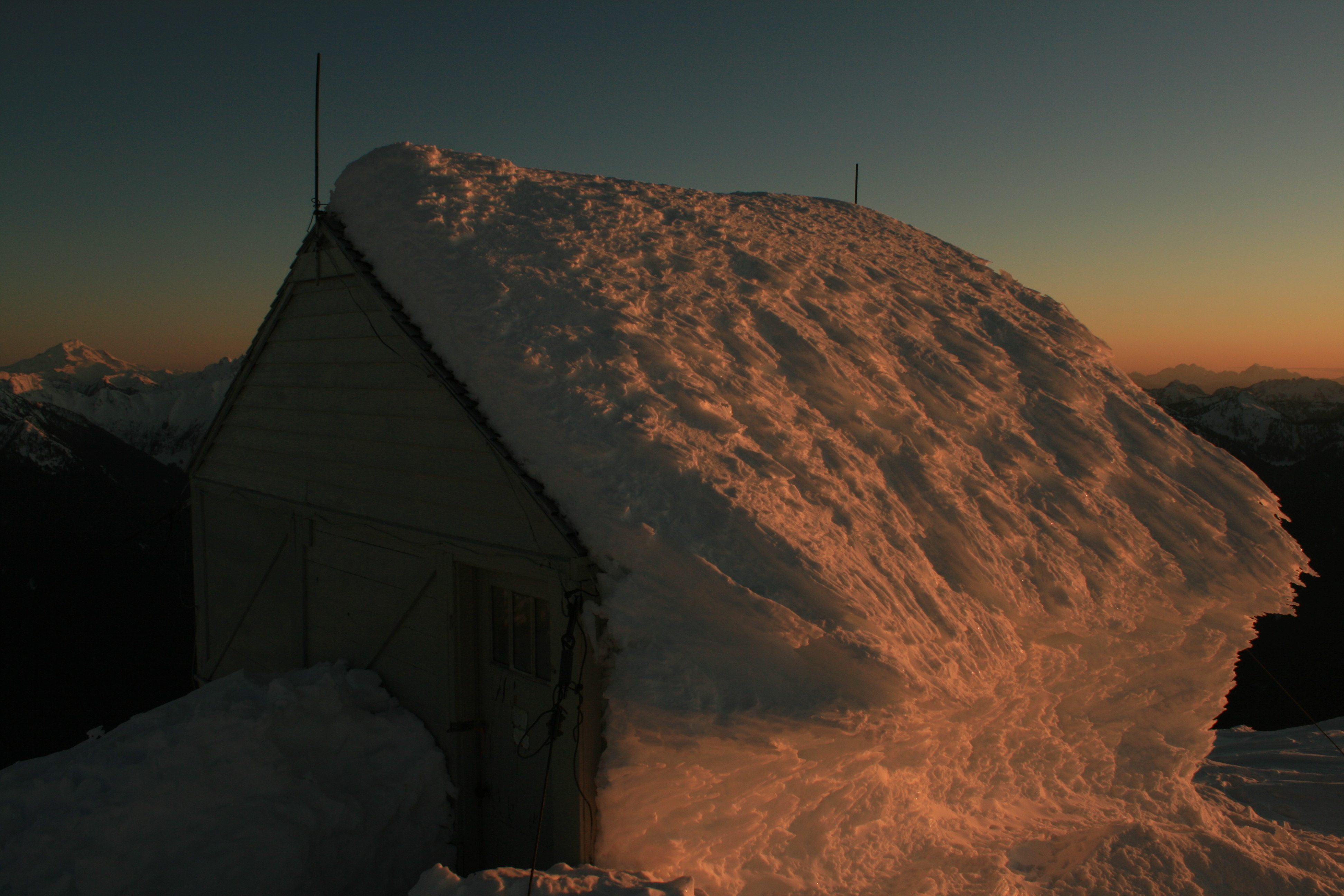
Hidden Lakes Fire Lookout plastered with snow
Data Sources
Snow Telemetry Sites (SNOTEL)
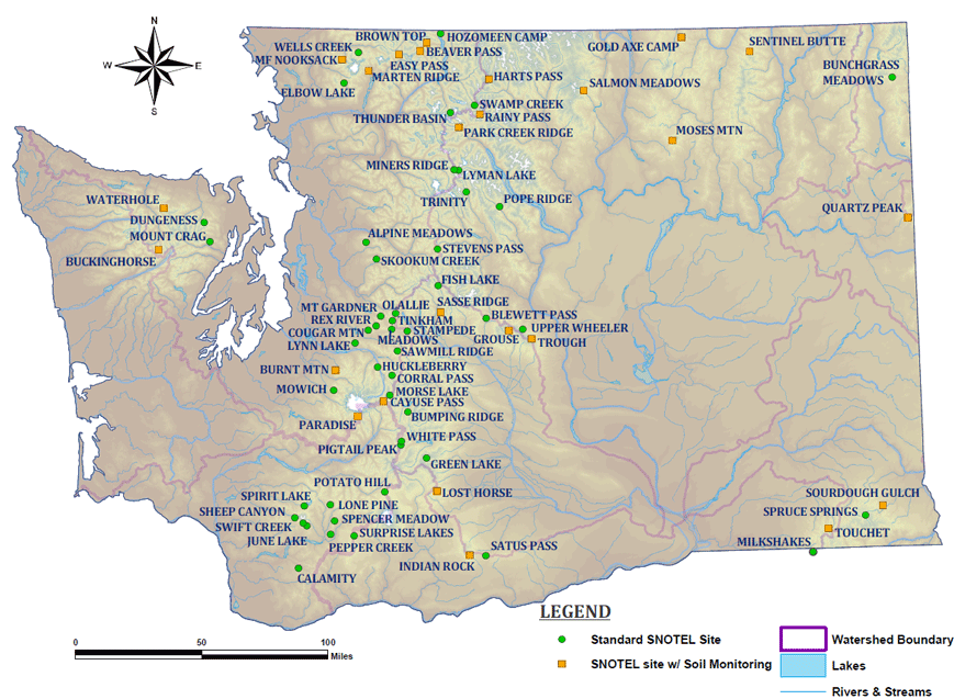
Washington State Snow Telemetry (SNOTEL) sites with elevation.
The Natural Resources Conservation Service (NRCS) maintains the Snowpack Telemetry (SNOTEL) network. These stations provide weather and snow data updated hourly stretching back decades. Different stations record different information, but almost all sites measure snow water equivilent (SWE), snow depth, precipitation, and temperature. There are 82 sites in Washington state. Data can be accessed with various methods:
SNOTEL data and products link.
National Operational Hydrologic Remote Sensing Center Data (NOHRSC)
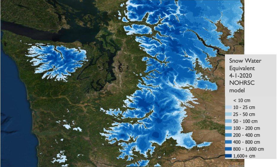
The National Operational Hydrologic Remote Sensing Center Data (NOHRSC) generates modelled snow and hydrological data which incorporates a sophisticated set of inputs and provides coverage for much of the continent with daily temporal resolution stretching back several decades. Data can be visualized at the following data portal, and can be downloaded from the data archive. Data can be prepared for analysis using ArcGIS software from the following methodology. This data is used in my research to visualize snowpack in the region and consider changes between years on a fixed date.
Current Snow Depth Visualization (US Forest Service
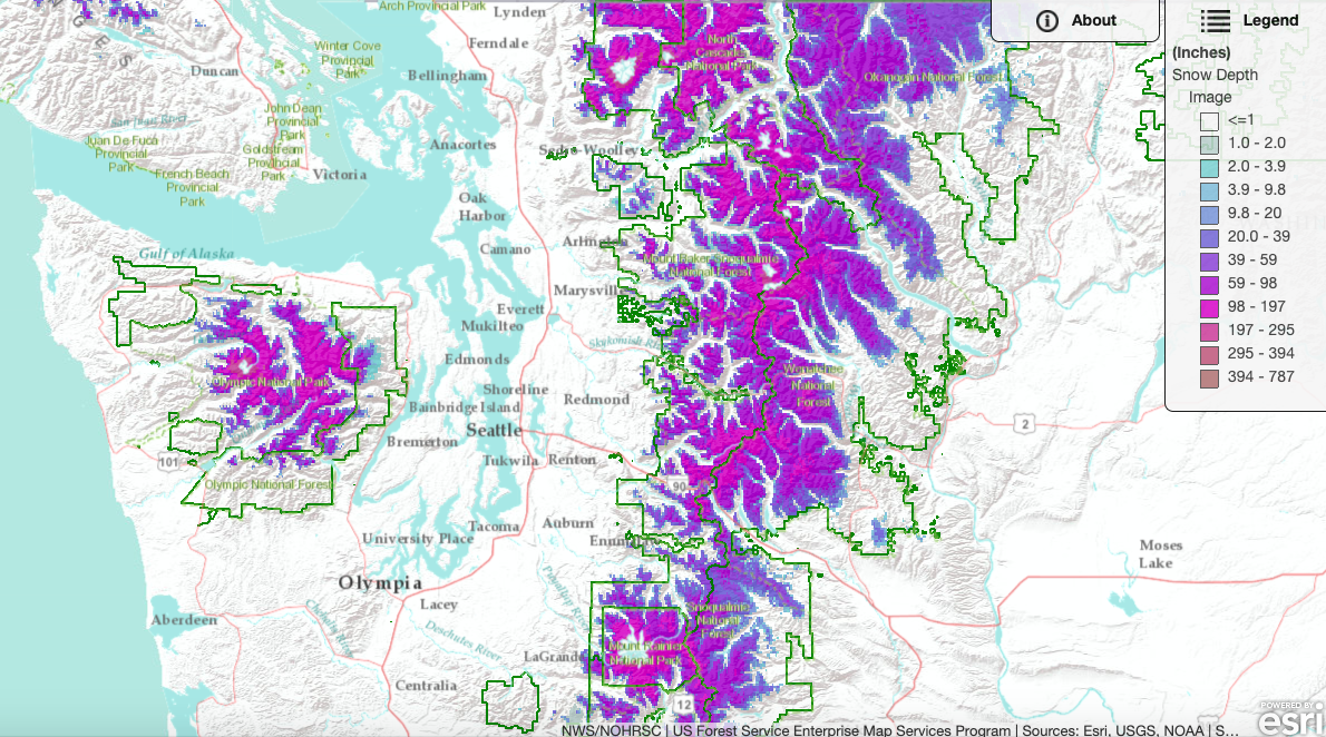
Link to FS map.
This map displays current snow depth according to the National Oceanic and Atmospheric Administration (NOAA) National Snow Analyses (NSA), which is a product of the NOHRSC. It is hosted by the USFS Pacific Southwest branch and defaults to the Sierra mountains of California, however the map shows the entire Western United States including Washington state. It is an effective visualization of the NOHRSC data described above.
Analysis
For Univesity of Washington course Civil and Envirornmental Engingeering Independent Study - Geospatial Data Analysis With Python (CEE 498 Winter 2021), I completed my final project investigating changes in snowpack in the Washington Cascades.
The course Github and material is located at the following link:
https://github.com/UW-GDA/gda_course_2021
My final project for the course is located at the following link:
https://github.com/UW-GDA/Cascades-Snowpack-Kakatsakis
Some notable figures, maps and findings from my snowpack analysis are included below:
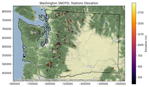 Washington SNOTEL sites by elevation classification. These sites provide the most in depth record of the snowpack of Washington. They are located throughout the mountains of the region, at a variety of elevations. Substantial gaps exist however where SNOTEL sites are not located, and the data they provide is far from complete.
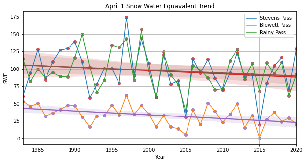 Snow Water Equivalent (SWE) from SNOTEL for end of season snowpack (April 1) at Stevens, Blewett, and Rainy Pass 1983-2020. Three notable mountain passes within the range are selected. Their yearly end of season measure of the water contained in the snowpack is plotted. A linear regression shows trend decreases in snow water equivilent over the 37 year period.
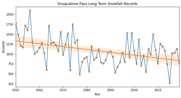
Longterm snowfall totals at Snoqualmie Pass. This data is sourced from the Washington State Department of Transportation and displays a long term record of how much snow is falling at Snoqualmie Pass, located just over 3000 feet above sea level. Interannual variation can be observed both on uncharacteristically dry and snowy years. A linear regression shows comprehensive decreases in snowfall at this area.
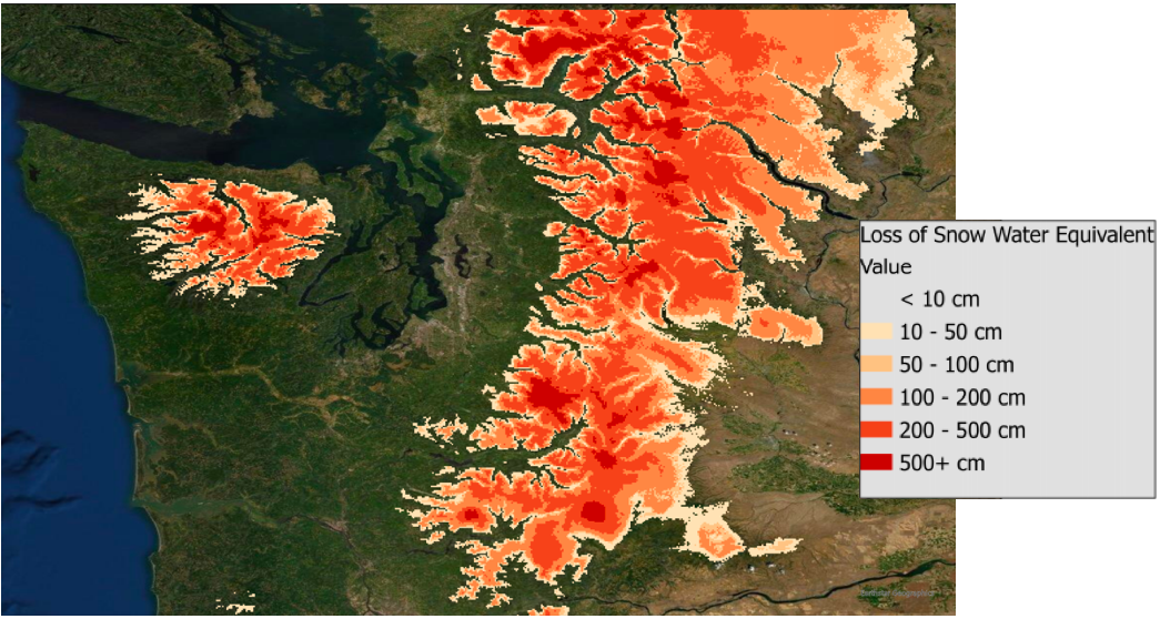
Estimated Snow Water Equivalent (SWE) loss from 2020-2050. This map shows an estimate of the amount of water in the snowpack which will no longer be present during a 30 year period. It is created using Raster manipulation of 2020 NOHRSC data, applying a 40% decrease in SWE.
Estimates from Relevant Literature
This project utilizes and relies on the research, models and estimates of expert individuals and organizations in associated fields. The following visualizations summarize some of the predicted impacts for Pacific Northwest snowpack throughout the 21st century.
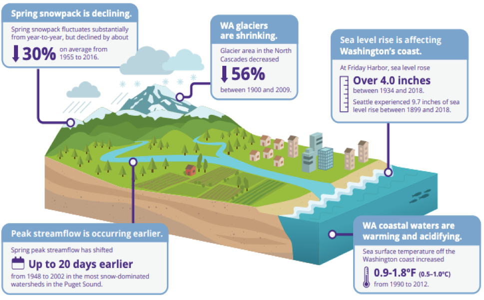
Roop et. al. 2020. An effective visualization of the observed hydrological impacts of climate change for Washington state. The University of Washington Climate Impacts Group prepared this in their descriptions of the implications for Washington state from the The Intergovernmental Panel on Climate Change’s Special Report on the Ocean and Cryosphere. These changes specific to the region are not merely predicted or hypothetical-- they are ongoing proccesses with discernable impacts.
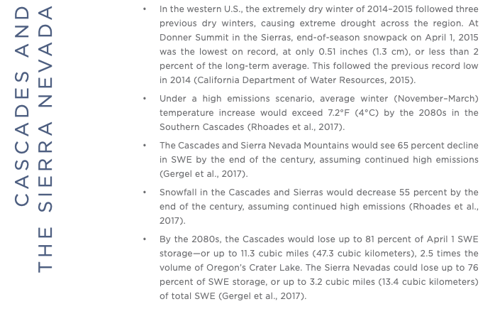
Hagestad, Protect Our Winters, 2018. Summary of end of century predicted snowpack impacts for both the Cascades and the Sierra Nevada. A frightening and massive decrease in snowpack predicted by one of the most influential orgnizations in the field, Protect Our Winters. POW is a nonprofit that focuses its efforts on legislation regarding climate change.
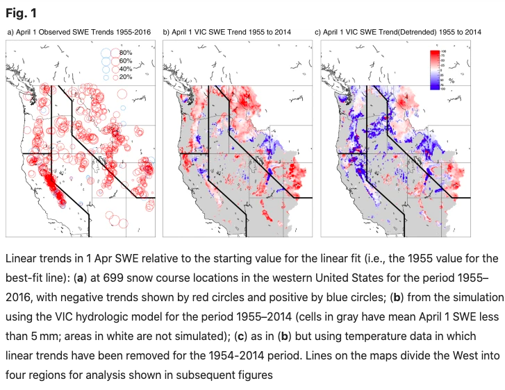
Mote et al. 2018. An examination of dramatic decline of snowpack in the Western US. Trends in SNOTEL SWE, and VIC, a hydrological model, are displayed shown across the nation over a long-term time scale. Comprehensive decreases in snowpack can be plainly observed.
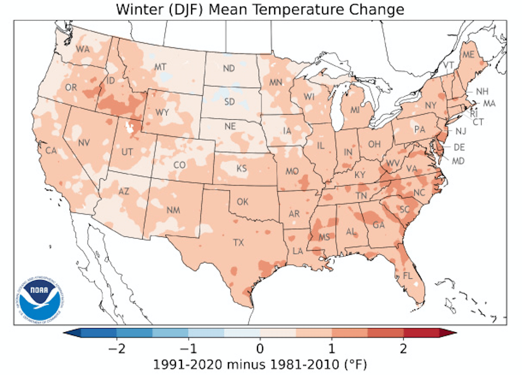
Credit National Oceanic and Atmospheric Administration (NOAA). Longterm changes in mean temperature show a warming across the United States, and undeniable evidence of warming in the Winter season. This map represents the latest "climate normal" which is utilized by NOAA, and shows how these normals are rapidly changing.
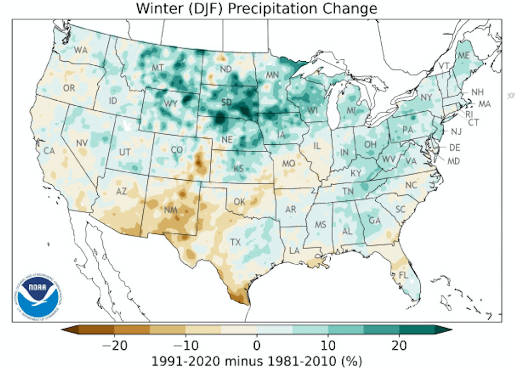
Credit National Oceanic and Atmospheric Administration (NOAA). Longterm changes in Winter precipitation show can greatly affect snowpack in different areas. Volaitle changes as a result of climate change creates an unpredictable outlook for snow falling as precipitation in the long term. Washington has a split outlook on Winter precipitation change, and will likely experience highly variable climate patterns in the coming years.
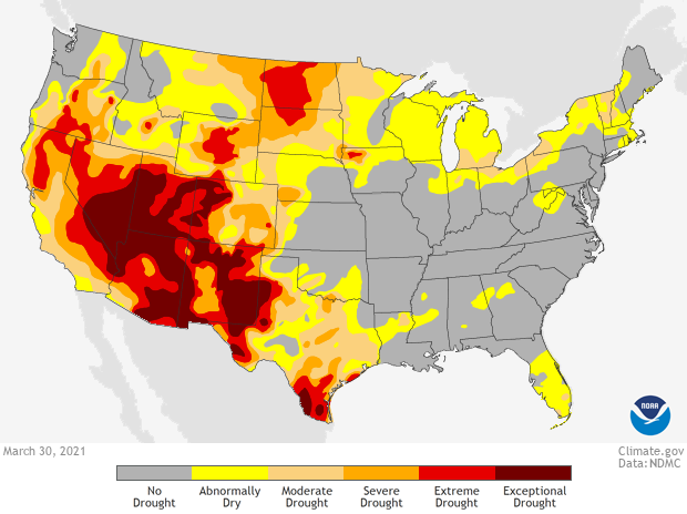
Credit National Oceanic and Atmospheric Administration (NOAA). Draught status for the United States at the end of Winter season in 2021. Washington remains relatively unaffected this year in part due to a healthy La Nina snowpack, however much of the Western United States is currently in a draught. During low snow years this outlook will become increasingly dangerous. Water shortage and wildfire hazard are major implications of draught, contributed to by diminished snowpack.